
Niveau d'étude visé
Bac +5
ECTS
120 crédits
Durée
2 ans
Composante
UFR Physique, Ingénierie, Terre, Environnement, Mécanique (PhITEM)
Langue(s) d'enseignement
Français, Anglais
Présentation
Le master Sciences de la terre et des planètes, environnement (STPE) est une formation en deux ans visant à acquérir des connaissances et des compétences de haut niveau dans l'étude des processus opérant à toutes les échelles dans le système terre, environnement. Il permet aux étudiants soit de poursuivre en doctorat, soit de se présenter sur le marché du travail.
L’objectif du master STPE est de former des étudiants aux outils modernes de la physique-mécanique, de la chimie et de la géologie, permettant d’aborder de façon quantitative les Sciences de la Terre et de l’environnement, qu’il s’agisse des études de physique du globe, de géodynamique, de climat, de risques naturels,
de pollution des sols et des eaux, d’explorations géologiques et géophysiques tout en maniant ces outils sur la base d’une très bonne connaissance de terrain. Un enjeu majeur est d’appliquer des sciences et techniques nouvelles, avec une large part donnée à la modélisation, aux problèmes actuels de société (transition énergétiques, ressources, changement climatique, risques naturels).
Le master est organisé autour de 6 parcours, dont 3 parcours formellement identifiés comme parcours internationaux. Tous les parcours sont définis sur les 2 ans du master et les étudiants choisissent un parcours en s’inscrivant en 1re année de master.
Formation internationale
- Formation tournée vers l’international
- Formation ayant des partenariats formalisés à l’international
- Doubles diplômes, diplômes conjoints, Erasmus Mundus
Organisation
Stage à l'étranger
En France ou à l'étranger
Période du stage
master 1re année : mai-juillet ; master 2e année : février - juin (peut se poursuivre jusqu'en septembre)
Programme
Sélectionnez un programme
Parcours Earth System Sciences 1re et 2e années
Le parcours "Sciences du Système Terre" est orienté vers la recherche, visant généralement -mais pas nécessairement- une thèse de doctorat. Le programme vise à la fois à offrir une connaissance robuste de la Terre solide, et à envisager la Terre solide comme appartenant à un système global, en analysant ses interactions avec ses enveloppes externes : l'hydrosphère, l'atmosphère, la cryosphère, la biosphère et les planètes.
Le parcours présente une offre large, avec de nombreuses options qui permettent de construire des chemins pédagogiques personnalisés, en concertation avec les responsables du parcours, de manière à ce que chaque semestre cumule 30 ECTS, incluant quelques UEs obligatoires et des UEs optionnelles.
La formation est conçue pour fournir conjointement des approches théoriques et pratiques, en s'appuyant très fortement sur l'enseignement sur le terrain.
Plusieurs UE, proposées aux M1 et M2 ensemble, sont bisannuelles (ouverte alternativement les années paires et impaires). Pour des raisons logistiques, de rares combinaisons d'options sont incompatibles.
Certaines UE optionnelles peuvent (rarement) ne pas être disponibles pour des raisons techniques ou administratives
L'enseignement se fera, pour certaines UEs, en partie en anglais.
********************************************************************
The Earth System Sciences program is aimed towards research, generally but not necessarily aiming for a doctoral thesis. The program aims both at offering a robust knowledge of the solid Earth and to envision the solid Earth as belonging to a global system, by analyzing the interactions with its external envelopes: the hydrosphere, atmosphere, cryosphere, biosphere, and planets.
The Earth System Sciences program offers a broad panel and mutiple options, which allow for individualized learning paths to be designed. Each semester cumulates 30 ECTS, with a nulber of options that are assembled in agrrement with the heads of the program.
Training is designed to jointly provide theoretical and practical approaches, with a strong component of field-based teaching classes.
Several UE are opened jointly to M1 and M2 student, on a biannual basis (alternatively opened during odd and even years).
Some of the optional UE are (rarely) unavaible, for technical or administrative reasons.
Teaching will be partly in English.
Facultatif
UE Lithosphere dynamics (2024-2025)
6 créditsUE Tectonics and surface processes (2025-2026)
6 créditsUE Petrology
6 créditsUE Atelier Terrain pétrologie / Petrology field course
3 créditsUE Plio-Quaternary climates and landforms (2024-2025)
3 créditsUE Solid Earth and the atmosphere, hydrosphere, biosphere (2025-2026)
3 créditsUE Surfaces planétaires
3 créditsUE Geophysical observation of the Earth
6 créditsUE Atelier rentrée - projet professionnel / Introductory Field Course - Professional project
3 créditsUE Programmation et environnements informatiques
3 créditsUE Physique et Chimie de la Terre / Physics and Chemistry of the Earth
6 créditsUE Géomécanique / Geomechanics
3 créditsUE Advanced- Plio-Quaternary climates and landforms (2024-2025)
3 créditsUE Advanced- Solid Earth and the atmosphere, hydrosphere, biosphere (2025-2026)
3 crédits
Facultatif
UE Télédétection et Projet SIG / Remote Sensing and GIS Project
6 créditsUE Analyse de Bassins / Basin analysis
6 créditsUE Atelier Terrain Sédimentaire / Sedimentology field course
3 créditsUE Atelier terrain multidisciplinaire / Multidisciplinary field course
6 créditsUE Atelier terrain Lautaret : interface Neige & atmosphère / Lautaret Field Course: Snow-Atmosphere interface
6 créditsUE Archives climatiques / Climate records
3 créditsUE Géodynamique Interne / Deep Earth Geodynamics
6 créditsUE Data sciences & Inverse problems
3 créditsUE Dynamique et risque volcanique / Volcanic dynamics and hazards
3 créditsUE Environment records
3 créditsUE Scientific computing
3 créditsUE Sciences, pseudosciences, & pensée critique
3 crédits
Facultatif
UE Lithosphere dynamics (2024-2025)
6 créditsUE Tectonics and surface processes (2025-2026)
6 créditsUE Atelier Terrain tectonique-métamorphisme / Tectonics-Metamorphism field course
3 créditsUE Active Faults
6 créditsUE Intérieurs planétaires
3 créditsUE Dynamique des fluides géophysiques
6 créditsUE Changement climatique / Climate change
6 créditsUE Ecologie, biogéographie, évolution
3 créditsUE Fieldtrip Mountain Building, Climate, and biodiversity
6 créditsUE Solid Earth and the atmosphere, hydrosphere, biosphere (2025-2026)
3 créditsUE Plio-Quaternary climates and landforms (2024-2025)
3 créditsUE Advanced- Plio-Quaternary climates and landforms (2024-2025)
3 créditsUE Advanced- Solid Earth and the atmosphere, hydrosphere, biosphere (2025-2026)
3 crédits
UE Stage court
6 créditsUE Stage long
24 crédits
Parcours Géoressources 1re et 2e années
+++ for the English version, please see below +++
Pour répondre aux demandes énergétiques et matérielles du 21e siècle une exploration durable des ressources de notre planète et nécessaire, gérée par des spécialistes d’exploration avec une forte connaissance en géologie et en géophysique. Le parcours Géoressources a été créé pour répondre à ce besoin. La formation est organisée sur deux ans avec une série d'unités d'enseignement en commun avec d'autres parcours de la mention ainsi que des unités d'enseignement spécifiques au parcours. La formation sur le terrain, en entreprise ou en laboratoire de recherche joue un rôle clef dans ce parcours.
L'objectif du parcours Géoressources est de former les étudiants en géologie et géophysique pour travailler dans la recherche et/ou dans le secteur privé sur l'exploration minière ou des ressources énergétiques.
La formation est très axée sur l’enseignement par le terrain ; jusqu’à 24 ECTS de modules de terrain peuvent être choisis dans ce parcours. Le terrain constitue un aspect fondamental d’une formation en sciences de la terre et de l’environnement. La localisation privilégiée de Grenoble fait de la formation sur le terrain une « image de marque », les Alpes offrant un terrain géologique très riche.
Cette pratique de terrain est complétée par d'importantes activités pédagogiques numériques, réalisées sous forme de TP ou de projets. Nous mettons un accent important sur les outils les plus modernes d’exploration quantitative de la terre et de son environnement. Les outils de mesures géophysiques sont complétés par les outils d'interprétation, comme la modélisation numérique, le traitement de signal, la télédétection et l’interprétation sismique. Le soutien du Labex OSUG@2020 a été essentiel pour mettre en place ou renouveler un nombre important de ces outils.
La plupart des modules « outils » (i.e., modélisation numérique, télédétection/SIG) sont organisés sous forme de projets, de sorte que les étudiants puissent appliquer ces outils à un mini-problème en accord avec leur choix de parcours et leurs intérêts. Plusieurs UE disciplinaires se font également en partie sous forme de projet tuteuré, où les étudiants travailleront en petit groupe à la résolution d’un problème de type sociétal.
Certaines UE sont communes aux semestres 7 et 9. Ces UE ne sont ouvertes qu'une année sur deux :
- UE ouvertes les années paires (2016, 2018...) : Dynamique de la lithosphère, Atelier de terrain tectonique - métamorphisme, Méthodes d'exploration géochimiques et minéralogiques
- UE ouvertes les années impaires (2017, 2019...) : Pétrologie, Atelier de terrain pétrologie, Atelier grands défis sociétaux et économiques concernant les géo ressources
Les UE du semestre 9 sont enseignés en anglais ainsi qu’au moins 1 module de l’année de master 1re année. L’option Géo ressources+ donne aux étudiants l’opportunité de prendre des cours supplémentaires en économie de l’énergie et des ressources, proposés dans le master Economie de l’énergie et du développement durable.
Ce Parcours de Master vous donne la possibilité de candidater à la Graduate School de l’UGA et l’un de ses 15 programmes thématiques. La Graduate School UGA est un nouveau programme de formation par et pour la recherche qui a été lancé en 2021 au sein de l'Université Grenoble Alpes, et qui concerne l'ensemble des écoles et composantes de l'UGA.
L’objectif de ces programmes thématiques est d’offrir aux étudiants intéressés un programme de formation interdisciplinaire et d’excellence académique alliant cursus universitaire et stages en laboratoires. Chaque programme thématique développe un axe de recherche précis, permettant ensuite de poursuivre en thèse, ou d’avoir une insertion professionnelle directe.
Le programme regroupe des étudiants venant de mentions, parcours de Master ou filières d'ingénieurs différents et travaillant ensemble dans des enseignements spécifiques.
La participation à la Graduate School @UGA s’entend sur 2 ans (M1 et M2) et peut ouvrir la possibilité d’obtenir une bourse académique pour 2 ans pour les meilleurs étudiants internationaux (bacheliers non français).
Pour plus d’informations : https://www.univ-grenoble-alpes.fr/formation/graduate-school/
----------------------------------------------
To meet the energy and material demands of the 21st century, sustainable exploration of our planet's resources is necessary, managed by exploration specialists with solid knowledge in geology and geophysics. The Georesources program has been created to respond to this need. The training is organised over two years with a series of modules in common with other programs in the specialisation, as well as modules specific to this program. Training in the field, in a company or in a research laboratory plays a key role in this program.
The aim of the Georesources program is to train students in geology and geophysics, with a view to working in research and/or the private sector in mining exploration or energy resources.
The Georesources+ option gives students the opportunity to take additional courses in the economics of energy and resources, offered by the master in Economy for energy and sustainable development.
This Master Course gives you the opportunity to apply to the UGA Graduate School and one of its 15 thematic programmes that add an interdisciplinary component to your studies. Terra is the thematic programme closest to this Course. The objective of the thematic programmes is to offer students an interdisciplinary study programme combining academic teaching and training through laboratory research. The programme brings together students from different majors, master's courses or engineering programmes and works together in specific courses. Participation in the @UGA Graduate School is for two years (M1 and M2) and may open the possibility of obtaining an academic scholarship for two years for the best international students (non-French baccalaureate holders).
More information on the Graduate School website
UE Novel analysis methods in geochemistry & mineralogy
6 créditsUE Physique et Chimie de la Terre / Physics and Chemistry of the Earth
6 créditsAu choix : 3 à 6 parmi 9
UE Géochimie des contaminants : I) interactions métaux/minéraux/matière organique dans les réservoirs terrestres
6 créditsUE Lithosphere dynamics (2024-2025)
6 créditsUE Géomécanique / Geomechanics
3 créditsUE Prospection Géophysique / Geophysical Prospecting
3 créditsUE Petrology
6 créditsUE Atelier rentrée - projet professionnel / Introductory Field Course - Professional project
3 créditsUE Géochimie des contaminants II) modélisation Phreeqc
3 créditsUE Croissance économique et limites planétaires: climat, biodiversité
3 créditsUE Atelier Terrain pétrologie / Petrology field course
3 crédits
UE Analyse de Bassins / Basin analysis
6 créditsUE Ressources minérales
3 créditsAu choix : 4 à 7 parmi 7
UE Atelier terrain multidisciplinaire / Multidisciplinary field course
6 créditsUE Géophysique d'exploration / Exploration geophysics
6 créditsUE Télédétection et Projet SIG / Remote Sensing and GIS Project
6 créditsUE Atelier Terrain Sédimentaire / Sedimentology field course
3 créditsUE Marine Geophysics
3 créditsUE Subsurface modelling
3 créditsUE Stratégie argumentative
3 crédits
UE Mineral Resources and Sustainable Development
3 créditsUE Field trip : Exploration and Mining Geology
3 créditsUE GéoReservoirs: caractérisation, évaluation, valorisation
6 créditsAu choix : 3 à 5 parmi 7
UE Drilling and borehole geophysics
6 créditsUE Near-Surface Geophysics
6 créditsUE Atelier Terrain tectonique-métamorphisme / Tectonics-Metamorphism field course
3 créditsUE Politiques environnementales / Environmental-politics
3 créditsUE Active Faults
6 créditsUE Lithosphere dynamics (2024-2025)
6 créditsUE Tectonics and surface processes (2025-2026)
6 crédits
UE Stage court
6 créditsUE Stage long
24 crédits
Parcours Natural Geological Hazards and Risks 1re et 2e années
+++ for the English version, please see below +++
![]()
For a presentation in english click this link.
Les risques naturels géologiques (séismes, mouvements de terrain, volcans, déformation de la croûte terrestre) présentent un enjeu fort dans nos sociétés. Ceci se traduit par une demande croissante de compréhension, de maîtrise et de gestion des risques telluriques, aussi bien en France qu'à l'international. Le parcours NATURAL GEOLOGICAL HAZARDS AND RISKS a été créé pour répondre à ce besoin et forme les étudiants à l'évaluation des risques naturels par des méthodes quantitatives et des outils géophysiques. Les étudiants se destinent à travailler soit dans la recherche (académique, semi-publique ou privée), soit dans les bureaux d'étude en charge de l'estimation des risques naturels ou de la reconnaissance géophysique des terrains superficiels, soit en collectivités territoriales.
La formation, organisée sur 2 ans dont de nombreux cours mutualisés avec d'autres parcours de la mention, combine des approches théoriques et pratiques, et fournit un panel de compétences transverses aux différents risques naturels. Les cours de première année permettent aux étudiants de maitriser l'utilisation des outils géophysiques, sismologiques, de télédétection et de modélisation numérique. En deuxième année, l'accent est porté sur l'utilisation de ces outils pour la quantification des risques sismiques, gravitaires et volcaniques. En deuxième année, un grand nombre d'heures de formation sont dispensées sous la forme de projets (mélange de cours, études de cas et applications, évaluation sur rapports et présentations orales).
Les promotions intègrent quasiment tous les ans des étudiants étrangers. Ainsi les enseignements se font en anglais.
Le parcours est également adossé à un Programme Thématique (PT Risk), qui rassemble des étudiants de l'UGA travaillant sur les risques en général (technologiques, naturels, …). Cette ouverture est proposée aux étudiants sur sélection dès la première année, afin d'approfondir leur connaissance de la gestion des risques. Pour une présentation du PT Risk, suivez ce lien ou ce teaser.
La formation sur le terrain, en entreprise ou en laboratoire de recherche joue un rôle clef dans ce parcours. Le stage de fin de master (entre 4 et 6 mois) a lieu soit en bureau d'étude, soit dans la recherche académique (~25% des étudiants), soit dans les collectivités territoriales, en France ou à l'étranger (~20% des étudiants chaque année).
---------------------------------------------------------------
Natural geological hazards (earthquakes, landslides, volcanoes, deformation of the earth's crust) are a major issue in our societies. This is reflected in a growing demand for understanding, controlling and managing telluric risks, both in France and internationally. The NATURAL GEOLOGICAL HAZARDS AND RISKS program was created to meet this need and trains students in the assessment of natural hazards using quantitative methods and geophysical tools. Students are prepared to work either for research (academic, semi-public or private), or for engineering offices in charge of natural hazard assessment or geophysical reconnaissance of surface terrain, or for local authorities.
The training is organized over two years and includes courses shared with the other programs of the master. It combines theoretical and practical approaches, and provides a range of cross-disciplinary skills for the various natural hazards. The first-year courses allow students to master the use of geophysical, seismological, remote sensing and numerical modeling tools. In the second year, the focus is on the use of these tools for the quantification of seismic, landslide and volcanic hazards and risks. In the second year, a large number of training hours are given in the form of projects (a mix of lectures, case studies and applications, evaluation on reports and oral presentations).
Almost every year, the classes include foreign students. Thus, the teaching is done in English.
The program is also associated to a Thematic Program (PT Risk), which brings together UGA students working on risks in general (technological, natural, etc.). This opening is offered to students on selection from the first year, in order to deepen their knowledge of risk management. To know more on this PT Risk, follow this link or the teasers.
Training in the field, in companies or in research laboratories, plays a key role in this program. The end-of-master's internship (lasting between 4 and 6 months) takes place either in an engineering office, or in academic research (~25% of students), or in local authorities, in France or abroad (~20% of students each year).
UE Signal Processing
6 créditsUE Atelier rentrée - projet professionnel / Introductory Field Course - Professional project
3 créditsUE Programmation et environnements informatiques
3 créditsFacultatif
UE Geophysical observation of the Earth
6 créditsUE Gestion des risques : approches réglementaires et alternatives
6 créditsUE Tectonics and surface processes (2025-2026)
6 créditsUE Géomécanique / Geomechanics
3 créditsUE Prospection Géophysique / Geophysical Prospecting
3 créditsUE Professional and Scientific Communication 1
3 créditsUE Waves Physics
3 créditsUE Physique et Chimie de la Terre / Physics and Chemistry of the Earth
6 crédits
UE Introduction au risque sismique
6 créditsUE Dynamique et risque volcanique / Volcanic dynamics and hazards
3 créditsUE Dynamique et risque volcanique avancé / Advanced volcanic dynamics and hazards
3 créditsUE Mouvements de terrain, avalanches, ouvrages de protection
6 créditsFacultatif
UE Géophysique d'exploration / Exploration geophysics
6 créditsUE Télédétection et Projet SIG / Remote Sensing and GIS Project
6 créditsUE Data sciences & Inverse problems
3 créditsUE Instrumentation for geophysics
3 créditsUE Introduction to Machine learning in Earth Sciences
3 créditsUE Scientific computing
3 créditsUE Sismicité induite / Induced seismicity
3 crédits
UE Advanced gravitational risk
6 créditsUE Engineering seismology
6 créditsUE Project in engineering seismology [seismic vulnerability, site characterization, ground motion simulation]
3 créditsUE Project in gravitational risk [multi-method approach]
3 créditsAu choix : 2 à 4 parmi 9
UE Active Faults
6 créditsUE Gestion des risques : approches réglementaires et alternatives
6 créditsUE Near-Surface Geophysics
6 créditsUE Quantitative seismology
6 créditsUE Advanced Machine Learning in Earth Sciences
3 créditsUE Computing and data analysis Project
3 créditsUE Numerical Modelling
3 créditsUE Tectonics and surface processes (2025-2026)
6 créditsUE Signal Processing
6 crédits
UE Stage court
6 créditsUE Stage long
24 crédits
Parcours Geophysics and Earth Imaging 1re et 2e années
The "Geophysical Imaging of the Earth" program is for students interested in the understanding and evolution of the Earth's internal processes and structures, at different scales. It addresses several aspects of geophysics: environmental geophysics (changes in the cryosphere related to global warming, geothermal energy, hydrology, natural hazards...), fundamental geophysics (study of fault zones and earthquakes, volcano studies and monitoring, deep Earth dynamics...) and multi-scale and multi-physics imaging/monitoring.
These structures are mainly understood by their seismic, magnetic, electrical or gravimetric signatures, and their deformation movements. In the era of Big Data, the teaching is therefore resolutely oriented towards i) the acquisition of data during field and/or laboratory experiments, ii) the use of continuous observatory-type data, iii) their analysis via signal processing methods, as well as iv) their modelling and inversion by classical and advanced approaches (machine learning, use of numerical models...)
The students trained in the Geophysical Imaging of the Earth program will be able to demonstrate their skills as geophysical engineers and apply for jobs offered by design offices, public research institutes or large industrial groups concerned with the imaging, characterization and temporal monitoring of the physical properties of underground environments and their natural reservoirs in various environments. The main applications of this work are in the fields of seismology, civil engineering, natural hazard assessment, natural resource exploration and production including geothermal and hydrology, and the storage of fluids or solid wastes underground. There are many opportunities for internships in Earth science research laboratories (ISTerre in Grenoble), but also in operational research offices (BRGM) or in companies and design offices. The course also opens the way to a PhD.
UE Geophysical observation of the Earth
6 créditsUE Physique et Chimie de la Terre / Physics and Chemistry of the Earth
6 créditsUE Signal Processing
6 créditsUE Programmation et environnements informatiques
3 créditsUE Waves Physics
3 créditsAu choix : 2 parmi 3
UE Géodynamique Interne / Deep Earth Geodynamics
6 créditsUE Géophysique d'exploration / Exploration geophysics
6 créditsUE Data sciences & Inverse problems
3 créditsUE Dynamique et risque volcanique / Volcanic dynamics and hazards
3 créditsUE Instrumentation for geophysics
3 créditsUE Introduction to Machine learning in Earth Sciences
3 créditsUE Scientific computing
3 créditsAu choix : 1 parmi 2
UE Marine Geophysics
3 créditsUE Sismicité induite / Induced seismicity
3 crédits
UE Frontiers in seismic imaging (Noise + FWI)
6 créditsUE Quantitative seismology
6 créditsUE Advanced signal Processing
3 créditsUE Computing and data analysis Project
3 créditsAu choix : 2 à 4 parmi 5
UE Active Faults
6 créditsUE Doctoral School - InternalEarth@les Houches
6 créditsUE Near-Surface Geophysics
6 créditsUE Advanced Machine Learning in Earth Sciences
3 créditsUE Numerical Modelling
3 crédits
UE Stage court
6 créditsUE Stage long
24 crédits
Parcours Hydroressources et Qualité des Milieux 1re et 2e années
La prospection, la protection, et la gestion des eaux souterraines et de surface ainsi que la remédiation des sites et sols pollués ou des eaux usées requièrent des compétences scientifiques et des connaissances dans de multiples domaines tels que la géologie, la pédologie, la chimie, l'hydrologie, la physique et la microbiologie.
Le parcours Hydroressources et Qualité des Milieux vise à former des spécialistes des transferts de masse, c'est-à-dire des transferts d’eau et de substances dissoutes et particulaires, polluantes ou naturellement présentes, dans les différents compartiments hydrologiques que sont les rivières, les zones non saturées et saturées des sols et sous-sol, capables de répondre aux besoins des bureaux d’études, des entreprises, des collectivités territoriales et de la recherche académique.
Ce parcours anciennement ‘professionnalisant’ s'est élargi depuis une dizaine d’années au domaine de la recherche. Chaque année, environ 15-20% des étudiants continuent en thèse universitaire. La grande majorité des étudiants effectue donc des stages et s'insèrent dans les entreprises et collectivités. La formation existant depuis 1992, elle est reconnue dans le milieu professionnel des bureaux d’études et de travaux dans les domaines des sites et sols pollués, de l'hydrologie et de l'hydrogéologie. La majorité des cours sont délivrés en français. Certains cours peuvent néanmoins être délivrés en anglais. La maîtrise des deux langues en compréhension orale est donc requise.
En première année de master la période scolaire a lieu de tout début septembre à mi-avril, cette phase est suivie d’un stage d’une durée minimale de 2 mois en milieu universitaire ou en entreprise. En deuxième année, les cours se déroulent de septembre à fin janvier. Le stage de fin d’étude peut se faire en laboratoire de recherche universitaire ou en entreprise et collectivités territoriales. Il doit avoir une durée de 5 à 6 mois, commençant au plus tôt début février.
-------------------------------------------
Prospecting, protection, and more generally the management of groundwater, surface water and wastewater, as well as the remediation of polluted soils require scientific skills as diverse as geology, pedology, chemistry, physics and microbiology.
The Hydroressource and environmental quality course aims to train specialists in the mass transfer, i.e. the transfer of water and associated dissolved and particulate substances, pollutants, naturally present or not, in free surface waters (rivers), in unsaturated and saturated zones of soils and subsoils, and this in industrial application and associated academic research fields.
Most of the students do internships in private companies. As the formation exists since 1992, it is recognized in the environmental consulting and engineering sectors on a national level in the remediation of polluted soils, hydrology, hydrogeology. This formerly 'professionalizing' course has also been open to research since 10 years, with an average of 15-20% students per year continuing on to a PhD thesis.
The majority of the courses are given in French. Some courses may be taught in English. Mastery of both languages in oral comprehension is therefore required.
In the first year of the Master's program, the academic period takes place from the beginning of September to mid-April, followed by an optional internship of at least two months in a university or private or public company. In the second year, the end-of-study internship, always either in a university research laboratory or in a company, lasting a minimum of 5 months and a maximum of 6 months, begins at the earliest in February.
UE Air, soil, water : introduction to environmental pollutants modelling
6 créditsUE Climatic and Environmental variability
6 créditsUE Géochimie des contaminants : I) interactions métaux/minéraux/matière organique dans les réservoirs terrestres
6 créditsUE Hydrologie et hydraulique / Hydrology and Hydraulics
6 créditsAu choix : 2 parmi 4
UE Hydrogéologie / Hydrogeology
6 créditsUE Professional and Scientific Communication 1
3 créditsAu choix : 4 à 5 parmi 6
UE Atelier terrain Lautaret : interface Neige & atmosphère / Lautaret Field Course: Snow-Atmosphere interface
6 créditsUE Atelier terrain hydrologie et hydrométéorologie / Hydrology and Hydrometeorology Field Course
6 créditsUE Instrumentation et métrologie / Instrumentation and metrology
6 créditsUE Pollution atmosphérique : principes & méthodes expérimentales / Atmospheric pollution: Principles and Experimental Methods
6 créditsUE Télédétection et Projet SIG / Remote Sensing and GIS Project
6 créditsUE Environment records
3 crédits
UE Pollution et rémédiation
6 créditsUE Projets en Géochimie/Hydrologie et Qualité de l'Eau
6 créditsUE Transferts en milieu poreux / Transfer in Porous Media
6 créditsUE Hydrologie des systèmes continentaux / Continental Systems Hydrology
3 créditsUE Transferts dans les eaux de surface
3 créditsAu choix : 1 à 2 parmi 6
UE Water quality and treatment
6 créditsUE Emerging pollutions
3 créditsUE Hydrogeophysics for Hydrodynamic modeling
3 créditsUE Hydrogéophysique / Hydrogeophysics
3 créditsUE Hydrologie et climat
3 créditsUE Politiques environnementales / Environmental-politics
3 crédits
UE Stage court
6 créditsUE Stage long
24 crédits
Parcours Système Climatique : Atmosphère, Hydrosphère, Cryosphère 1re et 2e années
+++ for the English version, please see below +++
Le parcours Parcours Système Climatique : Atmosphère, Hydrosphère, Cryosphère vise à étudier les processus opérant dans le système climatique et leurs interactions. Comprendre le climat passé et présent et prévoir les changements futurs impliquent une connaissance précise de ces processus. Ce parcours s’intéresse à toutes les composantes superficielles de la Terre, l’atmosphère, les surfaces continentales (l’eau, la cryosphère, la biosphère) et l’océan. Il fait appel à une variété de disciplines et de compétences, en physique, chimie, mathématiques, géosciences, géographie, et informatique.
Le parcours forme des experts généralistes et a une finalité recherche mais répond aussi aux besoins grandissant des collectivité locale et des entreprises dans le domaine de l’environnement, comme par exemple en qualité de l’air, en hydrologie, ou en télédétection spatiale. L’enseignement s'appuie fortement sur les spécificités des laboratoires de recherche grenoblois dans le domaine du climat, de l'atmosphère et de la cryosphère / glaciologie (IGE, LEGI, INRAE, CEN). Le constat fait aujourd'hui est celui d'une poursuite en thèse pour 70% des étudiants (reflet du choix individuel plus que d’une sélection). Les outils utilisés dans le cadre des cours, ateliers, projets sont de fait aussi les outils utilisés dans le monde professionnel, ou en passe de l'être. L'ouverture plus grande vers le monde professionnel du parcours est menée à travers l'introduction d'UE professionnalisantes, ainsi qu'en prenant soin dans les modules généraux de faire systématiquement les liens nécessaires avec les applications « métiers » : variabilité climatique et intermittence des ressources en énergie renouvelable.
Le parcours comprend des stages terrain (1 semaine obligatoire + 1 optionelle + des journées ponctuelles), de nombreux travaux pratiques (e.g. 1 semaine en chimie atmosphère) qui permettent de mettre en pratique les connaissances théoriques.
Enfin, la formation comprend deux stages en laboratoire ou en entreprise, au choix, ont une place importante dans la formation. Ils se déroulent entre le M1 et le M2 (6 semaines minimum mais 2-3 mois recommandés) et à la fin du M2 (5 mois minimum). Pour ceux intéressés par une implication encore plus forte en recherche (2 stages de 5 mois sur les deux années), le parcours Research Intensive Track adossé au parcours Système Climatique peut être une option, à condition d'avoir déjà une expérience de master ou professionelle.
A noter qu'au premier semestre, il y a 30 ECTS de cours obligatoires, ce qui normalement est suffisant pour obtenir valider le semestre, les deux options proposées sont pour les cas particuliers. Au second semestre, le cours de télédétection et SIG est optionel mais fortement recommandé sauf si vous avez déjà une forte compétence dans le domaine ou un projet professionel précis qui justifie d'autres choix de modules.
Ce parcours de Master vous donne la possibilité de candidater à la Graduate School de l’UGA et l’un de ses 15 programmes thématiques qui ajoute un volet inter-disciplinaire à vos études. Terra est le programme thématique le plus proche de ce parcours. L’objectif des programmes thématiques est d’offrir aux étudiants un programme d'études interdisciplinaires alliant enseignement universitaire et formation par la recherche en laboratoire. Le programme regroupe des étudiants venant de mentions, parcours de Master ou filières d'ingénieurs différents et travaillant ensemble dans des enseignements spécifiques. La participation à la Graduate School @UGA s’entend sur 2 ans (M1 et M2) et peut ouvrir la possibilité d’obtenir une bourse académique pour 2 ans pour les meilleurs étudiants internationaux (bacheliers non français). Plus d’information sur le site de la Graduate School
--------------------------------------------------------------------
The Climate System: Atmosphere, Hydrosphere, Cryosphere course aims to study the processes operating in the climate system and their interactions. Understanding past and present climate and predicting future changes requires a precise knowledge of these processes. This Course addresses all the surface components of the Earth, the atmosphere, the continental surfaces (water, cryosphere, biosphere) and the ocean. It draws on a variety of disciplines and skills, including physics, chemistry, mathematics, geosciences, geography, and computer science.
The course trains generalist experts and has a research focus, but also responds to the growing needs of local authorities and companies in the field of the environment, for example in air quality, hydrology, or remote sensing. The teaching relies heavily on the specificities of Grenoble's research laboratories in the field of climate, atmosphere and cryosphere and glaciology (IGE, LEGI, INRAE, CEN). The observation made today is that 70% of the students pursue a PhD after this master (reflecting individual choice rather than any selection). The tools used in the courses, workshops and projects are in fact also the tools used in the professional world, or in the process of being used. The course's greater openness to the professional world is achieved through the introduction of professionally oriented courses, as well as by taking care in the general modules to systematically make the necessary links with "business" applications: climate variability and intermittency of renewable energy resources.
The course includes fieldwork (1 compulsory week + 1 optional week + occasional days), numerous practical assignments (e.g. 1 week in atmospheric chemistry) which allow theoretical knowledge to be put into practice.
Finally, the course includes two internships in a laboratory or in a company, of one's choice. These internships take place between M1 and M2 (6 weeks minimum but 2-3 months recommended) and at the end of M2 (5 months minimum). For those interested in an even stronger involvement in research (2 internships of 5 months over the two years), the Research Intensive Track associated to the Climate System Course may be an option, provided that you already have a master's or professional experience.
Note that in the first semester, there are 30 ECTS of compulsory courses in the program, which is sufficient to obtain validation of the semester, the two options proposed are for special cases and not necessarily open every year. In the second semester, the remote sensing and GIS course is marked as optional but is strongly recommended unless you already have a strong competence in the field or a specific professional project that justifies other module choices.
This Master Course gives you the opportunity to apply to the UGA Graduate School and one of its 15 thematic programmes that add an interdisciplinary component to your studies. Terra is the thematic programme closest to this Course. The objective of the thematic programmes is to offer students an interdisciplinary study programme combining academic teaching and training through laboratory research. The programme brings together students from different majors, master's courses or engineering programmes and works together in specific courses. Participation in the @UGA Graduate School is for two years (M1 and M2) and may open the possibility of obtaining an academic scholarship for two years for the best international students (non-French baccalaureate holders).
More information on the Graduate School website
UE Air, soil, water : introduction to environmental pollutants modelling
6 créditsUE Climatic and Environmental variability
6 créditsUE Hydrologie et hydraulique / Hydrology and Hydraulics
6 créditsUE General Physical Meteorology
3 créditsUE Mécanique des fluides / Fluid Mechanics
3 créditsUE Professional and Scientific Communication 1
3 créditsAu choix : 1 parmi 2
UE Atelier terrain Lautaret : interface Neige & atmosphère / Lautaret Field Course: Snow-Atmosphere interface
6 créditsUE Pollution atmosphérique : principes & méthodes expérimentales / Atmospheric pollution: Principles and Experimental Methods
6 créditsAu choix : 3 à 5 parmi 7
UE Atelier terrain hydrologie et hydrométéorologie / Hydrology and Hydrometeorology Field Course
6 créditsUE Instrumentation et métrologie / Instrumentation and metrology
6 créditsUE Télédétection et Projet SIG / Remote Sensing and GIS Project
6 créditsUE Archives climatiques / Climate records
3 créditsUE Introduction to Machine learning in Earth Sciences
3 créditsUE Environmental flows
3 créditsUE Environment records
3 crédits
Au choix : 5 à 10 parmi 15
UE Changement climatique / Climate change
6 créditsUE Cryosphère / Cryosphere
6 créditsUE Dynamique des Fluides Géophysiques / Geophysical Fluid Dynamics
6 créditsUE Transfert radiatif et Télédétection / Radiative Transfer and Remote Sensing
6 créditsUE Advanced Machine Learning in Earth Sciences
3 créditsUE Computing and data analysis Project
3 créditsUE Geostatistics
3 créditsUE Hydrologie des systèmes continentaux / Continental Systems Hydrology
3 créditsUE Hydrologie et climat
3 créditsUE Numerical Modelling
3 créditsUE Ocean dynamics
3 créditsUE Wave dynamics
3 créditsUE Data assimilation in geosciences
3 créditsUE Atmospheric boundary layer: from fundamentals to air quality
3 créditsUE Modèles pour la chimie de l'atmosphère
3 crédits
UE Stage court
6 créditsUE Stage long
24 crédits
Admission
Conditions d'admission
La 1re année de master est ouverte aux personnes qui ont obtenu un diplôme national conférant le grade de licence dans un domaine compatible avec celui du master ou via une validation d’études ou d’acquis.
L’entrée en 2e année de master peut être sélective. Elle est ouverte sur dossier aux candidats titulaires d'une première année de master dans le domaine.
Public formation continue : Vous relevez de la formation continue :
- si vous reprenez vos études après 2 ans d'interruption d'études
- ou si vous suiviez une formation sous le régime formation continue l’une des 2 années précédentes
- ou si vous êtes salarié, demandeur d'emploi, travailleur indépendant
Si vous n'avez pas le diplôme requis pour intégrer la formation, vous pouvez entreprendre une démarche de validation des acquis personnels et professionnels (VAPP)
Pour plus d'informations, consultez la page web de la Direction de la formation continue et de l’apprentissage
Vous pouvez également Consulter les tarifs s'appliquant aux publics de la formation continue.
----------------------------------------------------------
- The 1st year is open to students who have obtained a national diploma equivalent to a bachelor degree (licence) in a field compatible with that of the master, or via a validation of their studies or experience
- Entry to the 2nd year may be selective. It is open to candidates who have completed the first year of a master in the field, subject to a review of their application
Public continuing education : You are in charge of continuing education :
- if you resume your studies after 2 years of interruption of studies
- or if you followed training under the continuous training regime one of the previous 2 years
- or if you are an employee, job seeker, self-employed
If you do not have the diploma required to integrate the training, you can undertake a validation of personal and professional achievements (VAPP)
Candidature
Vous souhaitez candidater et vous inscrire à cette formation?
Laissez-vous guider simplement en suivant ce lien
----------------------------------
You want to apply and sign up for a master? Please be aware that the procedure differs depending on the diploma you want to take, the diploma you have already obtained and, for foreign students, your place of residence.Let us be your guide – simply follow this link
Public cible
- Étudiants en formation initiale ayant obtenu une licence en Sciences de la terre, physique ou mécanique
- Étudiants étrangers souhaitant poursuivre leurs études en Sciences de la terre et de l'environnement en France
- Étudiants en formation continue souhaitant se perfectionner dans le domaine des Sciences de la terre et de l'environnement
-------------------------------------------------------
- Students in initial training with a bachelor's degree in Earth sciences, Physics, or Mechanics
- Foreign students wishing to pursue their studies in Earth sciences and the Environment in France
- Students in continuing education wishing to improve in the field of Earth sciences and the environment
Droits de scolarité
Pré-requis obligatoires
Le master mettant l'accent sur les outils permettant d’aborder de façon quantitative les Sciences de la terre et de l’environnement (quelque soit le parcours), un bon niveau en mathématiques et physique est exigé. Ceci est particulièrement vrai pour le parcours Géophysique, qui s'adresse en premier lieu aux étudiants sortant d'une licence de Physique ou Mécanique.
-----------------------------------------------------
The master focuses on the tools to quantitatively address the Earth and environmental sciences (whatever the course), a good level in mathematics and physics is required. This is particularly true for the Geophysics course, which is primarily aimed at students with a degree in physics or mechanics.
Pré-requis recommandés
Pour le parcours Géoressources, un bon niveau en géologie (y inclus avec des expériences de terrain) est fortement recommandé.
L'enseignement étant donné en partie en anglais, un bon niveau d'anglais est exigé à l'entrée du master (de préférence niveau B2). Le niveau B2 en anglais est obligatoire en sortie de master pour obtenir le diplôme. Il n'y a pas de cours d'anglais intégré au master, mais des enseignements en anglais ; il est de la responsabilité des étudiants d'atteindre le niveau B2 au moins à la fin du master.
Et après
Métiers visés
Les parcours Géodynamique et Atmosphère, climat, surfaces continentales préparent principalement à une poursuite en thèse. Les autres parcours sont des parcours mixtes (Recherche, développement et innovation) qui préparent aussi bien à l’intégration du marché du travail à bac + 5 - bac + 8. Ces débouchés sont :
- à bac + 5 : postes d’ingénieur dans les grandes compagnies énergétiques et minières, bureaux d’études en géologie, géophysique, environnement, collectivités locales et territoriales, organisations non-gouvernementales
- à bac + 8 : enseignement-recherche dans les EPST et EPIC, R & D dans les grandes compagnies énergétiques et minières, centres de recherche sur l’environnement, organismes internationaux et nationaux.
------------------------------------
At the end of the master's degree (bac + 5) : engineering positions in the major energy and mining companies ; engineering offices in geology, geophysics, environment ; local and territorial authorities ; non-governmental organizations
- After graduation (bac + 8): teaching-research in EPST, EPIC ; research and development in major energy and mining companies, environmental research centers, international and national organizations.
Les + de la formation
La formation est adossée aux laboratoires de recherche associés à l’OSUG (Observatoire des Sciences de l’Univers de Grenoble), plus particulièrement aux laboratoires :
- Institut des Sciences de la Terre – ISTerre (parcours Géodynamique, Géoressources, Géorisques, Géophysique, MEEES)
- Institut des Géosciences de l’Environnement IGE (parcours Atmosphère, Climat et Surfaces Continentales, Hydroressources, Hydrohasards)
Des liens étroits avec les autres laboratoires et équipes de l’OSUG existent également (LEGI/MEIGE ). Le Labex OSUG@2020 comporte un volet formation et soutient cette formation.
Le master est co-accrédité entre l'Université Grenoble Alpes et l'Institut polytechnique de Grenoble.
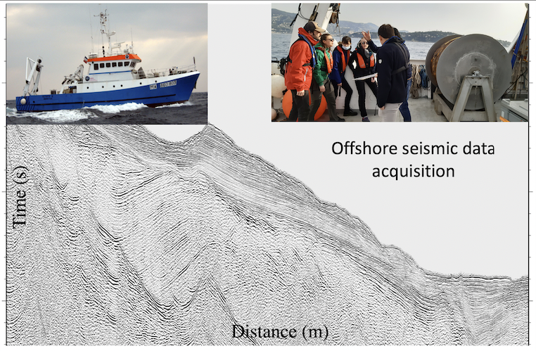
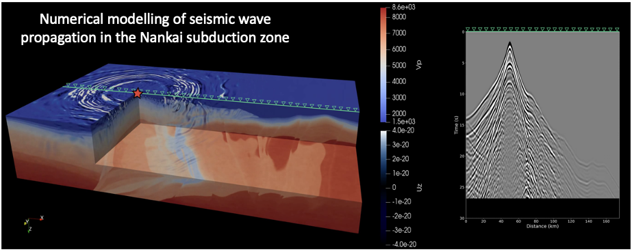
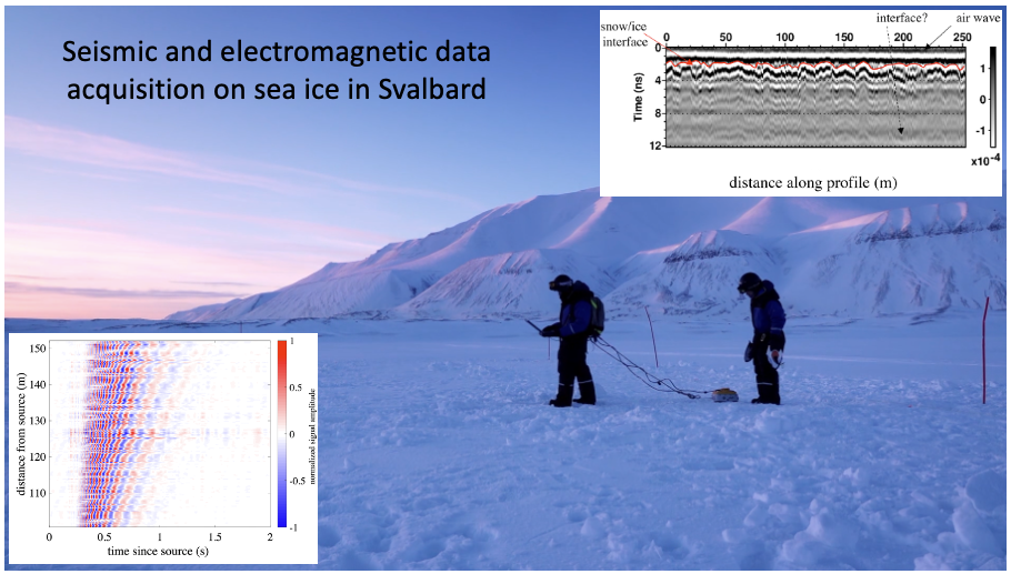
La formation est très axée sur l’enseignement par le terrain ; jusqu’à 24 ECTS de modules de terrain peuvent être choisis dans certains parcours. Le terrain constitue un aspect fondamental d’une formation en Sciences de la terre et de l’environnement. La localisation privilégiée de Grenoble fait de la formation sur le terrain une « image de marque » forte de notre master. Les Alpes offrent un terrain géologique très riche, mais également la possibilité d'étudier l'hydro-météorologie et les échanges cryosphère-atmosphère, dans le cadre de services d’observation de l'OSUG. Un atelier de terrain en géophysique marine est également proposé, en collaboration avec l’observatoire océanologique de Villefranche-sur-Mer.
Cette pratique de terrain est complétée par d'importantes activités pédagogiques numériques, réalisées sous forme de TP ou de projets. Un accent important est mis sur les outils les plus modernes d’exploration quantitative de la Terre et de son environnement. Les outils de mesures géophysiques ('monitoring environnemental') sont complétés par les outils d'interprétation, comme la modélisation numérique, le traitement de signal, la télédétection et l’interprétation sismique. Le soutien du Labex OSUG@2020 a été essentiel pour mettre en place ou renouveler un nombre important de ces outils.
La plupart des modules « outils » (i.e., modélisation numérique, télédétection/SIG) sont organisés sous forme de projets, de sorte que les étudiants puissent appliquer ces outils à un mini-problème en accord avec leur choix de parcours et leurs intérêts. Plusieurs UE disciplinaires se font également en partie sous forme de projet tuteuré, où les étudiants travailleront en petit groupe à la résolution d’un problème de type sociétal.
Les UE du semestre 9 sont enseignés en anglais ainsi qu’au moins 1 module de la 1re année de master. L'objectif est de présenter l’enseignement en anglais en cas de présence de non-francophones dans le public étudiant, aussi bien en 1re qu'en 2e année.
--------------------------------------
The course is supported by the research laboratories associated with the OSUG (Grenoble Universe Sciences Observatory) and the following in particular :
- Institute of Earth Sciences - ISTerre (Geodynamics, Georesources, Georisks, Geophysics, MEEES programs)
- Institute of Environmental Geosciences - IGE (Atmosphere-Climate-Continental landmass and Hydroressources programs)
There are also close links with the other laboratories and teams of the OSUG. The OSUG@2020 excellence laboratory includes a training component and supports this course.
The training is very focused on field teaching ; up to 24 ECTS of field modules can be selected in some courses. The field is a fundamental aspect of a training in Earth sciences and the environment. The privileged location of Grenoble makes field training a strong "brand image" of the master. The Alps offer a very rich geological terrain, but also the possibility to study hydro-meteorology and cryosphere-atmosphere exchanges, as part of the OSUG Observation services.
This field practice is complemented by important digital teaching activities, carried out in the form of practical work or projects. We place a strong emphasis on the most modern tools for quantitative exploration of the Earth and its environment. Geophysical measurement tools ('environmental monitoring') are supplemented by interpretation tools, such as numerical modeling, signal processing, remote sensing and seismic interpretation. The support of the OSUG @ 2020 Labex has been essential for setting up or renewing a large number of these tools.
Most of the "tools" (i.e., digital modeling, remote sensing / GIS) modules are organized as projects, so that students can apply these tools to a mini-problem in accordance with their choice of course and interests. Several disciplinary UEs are also partly in the form of a tutored project, where the students will work in a small group to solve a societal problem.
The 3 UEs are taught in English as well as at least 1 module of the year of master 1. Our policy is to present teaching in English in case of presence of non-French speakers in the student public, both in 1st year than in 2nd year.