Niveau d'étude
Bac +5
ECTS
6 crédits
Composante
UFR Physique, Ingénierie, Terre, Environnement, Mécanique (PhITEM)
Période de l'année
Automne (sept. à dec./janv.)
Description
Ce cours aborde les principales techniques géophysiques de caractérisation (et de suivi temporel) des couches superficielles (premières dizaines de mètres) avec des applications en risques naturels, environnement et en géotechnique. Il se veut très orienté données en combinant connaissances théoriques et méthodologiques, acquisitions et traitement de données, interprétation.
En pratique, il aborde les techniques de tomographies sismiques et électriques, d’inversions d’ondes de surface, de bruit sismique et de géoradar. Chacune de ces techniques sera illustrée lors de TD/TP avec des logiciels spécifiques, libres de droit. 2 sorties terrain seront organisées : une approche multiméthode de caractérisation d’un glissement de terrain qui constituera le projet principal du module et une seconde, concernant le géoradar et l’imagerie de structures sédimentaires.
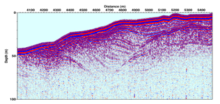
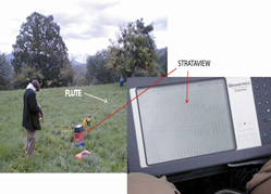
Figure 1 – Left : GPR imaging of ice accumulation in Antarctics. Right : Example of field seismic acquisition.
--------------------------------------------------------------------------------------------------------------------------------
This course covers the main geophysical techniques for characterizing (and of temporal monitoring) surface layers (the first few tens of meters), with applications to natural hazards, the environment and geotechnics. It is highly data-oriented, combining theoretical and methodological knowledge, data acquisition and processing, and interpretation.
In practical terms, it covers seismic and electrical tomography techniques, surface wave inversions, seismic noise and Ground Penetrating Radar. Each of these techniques will be illustrated during TD/TP sessions using specific, royalty-free software. 2 field trips will be organized: a multi-method approach to characterizing a landslide, which will be the module's main project, and a second, involving Georadar and imaging of sedimentary structures.
Heures d'enseignement
- UE Near-Surface Geophysics - TDTD6h
- UE Near-Surface Geophysics - CM/TDCours magistral - Travaux dirigés12h
- UE Near-Surface Geophysics - TPTP21h
- UE Near-Surface Geophysics - terrainTerrain9h
Pré-requis recommandés
Introduction aux méthodes de prospection géophysiques (sismique réfraction, sondages, cartographie) ; Traitement du signal.
--------------------------------------------------------------------------------------------------------------------------------
Introduction to geophysical prospecting methods (seismic refraction, boreholes, mapping); Signal processing.
Période
Semestre 9
Compétences visées
Savoir acquérir, traiter et interpréter des données de méthodes géophysiques dédiées à la caractérisation de la zone critique. Savoir mener un projet et rédiger un rapport.
--------------------------------------------------------------------------------------------------------------------------------
Know how to acquire, process and interpret data from geophysical methods dedicated to critical zone characterization. Know how to manage a project and write a report.