
Niveau d'étude visé
Bac +5
ECTS
120 crédits
Durée
2 ans
Composante
UFR PhITEM (physique, ingénierie, terre, environnement, mécanique)
Langue(s) d'enseignement
Anglais, Français
Présentation
+++ for the English version, please see below +++
![]()
For a presentation in english click this link.
Les risques naturels géologiques (séismes, mouvements de terrain, volcans, déformation de la croûte terrestre) présentent un enjeu fort dans nos sociétés. Ceci se traduit par une demande croissante de compréhension, de maîtrise et de gestion des risques telluriques, aussi bien en France qu'à l'international. Le parcours NATURAL GEOLOGICAL HAZARDS AND RISKS a été créé pour répondre à ce besoin et forme les étudiants à l'évaluation des risques naturels par des méthodes quantitatives et des outils géophysiques. Les étudiants se destinent à travailler soit dans la recherche (académique, semi-publique ou privée), soit dans les bureaux d'étude en charge de l'estimation des risques naturels ou de la reconnaissance géophysique des terrains superficiels, soit en collectivités territoriales.
La formation, organisée sur 2 ans dont de nombreux cours mutualisés avec d'autres parcours de la mention, combine des approches théoriques et pratiques, et fournit un panel de compétences transverses aux différents risques naturels. Les cours de première année permettent aux étudiants de maitriser l'utilisation des outils géophysiques, sismologiques, de télédétection et de modélisation numérique. En deuxième année, l'accent est porté sur l'utilisation de ces outils pour la quantification des risques sismiques, gravitaires et volcaniques. En deuxième année, un grand nombre d'heures de formation sont dispensées sous la forme de projets (mélange de cours, études de cas et applications, évaluation sur rapports et présentations orales).
Les promotions intègrent quasiment tous les ans des étudiants étrangers. Ainsi les enseignements se font en anglais.
Le parcours est également adossé à un Programme Thématique (PT Risk), qui rassemble des étudiants de l'UGA travaillant sur les risques en général (technologiques, naturels, …). Cette ouverture est proposée aux étudiants sur sélection dès la première année, afin d'approfondir leur connaissance de la gestion des risques. Pour une présentation du PT Risk, suivez ce lien ou ce teaser.
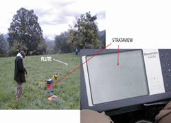
La formation sur le terrain, en entreprise ou en laboratoire de recherche joue un rôle clef dans ce parcours. Le stage de fin de master (entre 4 et 6 mois) a lieu soit en bureau d'étude, soit dans la recherche académique (~25% des étudiants), soit dans les collectivités territoriales, en France ou à l'étranger (~20% des étudiants chaque année).
---------------------------------------------------------------
Natural geological hazards (earthquakes, landslides, volcanoes, deformation of the earth's crust) are a major issue in our societies. This is reflected in a growing demand for understanding, controlling and managing telluric risks, both in France and internationally. The NATURAL GEOLOGICAL HAZARDS AND RISKS program was created to meet this need and trains students in the assessment of natural hazards using quantitative methods and geophysical tools. Students are prepared to work either for research (academic, semi-public or private), or for engineering offices in charge of natural hazard assessment or geophysical reconnaissance of surface terrain, or for local authorities.
The training is organized over two years and includes courses shared with the other programs of the master. It combines theoretical and practical approaches, and provides a range of cross-disciplinary skills for the various natural hazards. The first-year courses allow students to master the use of geophysical, seismological, remote sensing and numerical modeling tools. In the second year, the focus is on the use of these tools for the quantification of seismic, landslide and volcanic hazards and risks. In the second year, a large number of training hours are given in the form of projects (a mix of lectures, case studies and applications, evaluation on reports and oral presentations).
Almost every year, the classes include foreign students. Thus, the teaching is done in English.
The program is also associated to a Thematic Program (PT Risk), which brings together UGA students working on risks in general (technological, natural, etc.). This opening is offered to students on selection from the first year, in order to deepen their knowledge of risk management. To know more on this PT Risk, follow this link or the teasers.
Training in the field, in companies or in research laboratories, plays a key role in this program. The end-of-master's internship (lasting between 4 and 6 months) takes place either in an engineering office, or in academic research (~25% of students), or in local authorities, in France or abroad (~20% of students each year).
Formation internationale
Formation tournée vers l’international
Dimension internationale
Étudier à l’international en échange
Dans le cadre de cette formation, vous avez la possibilité de partir étudier durant un semestre ou une année dans un établissement partenaire de l’UGA à l’international.
Le correspondant relations internationales de votre composante pourra vous renseigner.
Plus d’informations sur : https://international.univ-grenoble-alpes.fr/partir-a-l-international/partir-etudier-a-l-etranger-dans-le-cadre-d-un-programme-d-echanges/
-----------------------------------------------------
Study abroad as an exchange student
As part of this track, you have the opportunity to study for a semester or a year at a UGA partner University abroad.
The International Relations Officers of your faculty will be able to provide you with more information.
More information on : https://international.univ-grenoble-alpes.fr/partir-a-l-international/partir-etudier-a-l-etranger-dans-le-cadre-d-un-programme-d-echanges/
Programme
Sélectionnez un programme
Master 1re année
UE Signal Processing
6 créditsUE Atelier rentrée - projet professionnel / Introductory Field Course - Professional project
3 créditsUE Programmation et environnements informatiques
3 créditsFacultatif
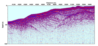
UE Geophysical observation of the Earth
6 créditsUE Gestion des risques : approches réglementaires et alternatives
6 créditsUE Tectonics and surface processes (2025-2026)
6 créditsUE Géomécanique / Geomechanics
3 créditsUE Prospection Géophysique / Geophysical Prospecting
3 créditsUE Professional and Scientific Communication 1
3 créditsUE Waves Physics
3 créditsUE Physique et Chimie de la Terre / Physics and Chemistry of the Earth
6 crédits
UE Introduction au risque sismique
6 créditsUE Dynamique et risque volcanique / Volcanic dynamics and hazards
3 créditsUE Dynamique et risque volcanique avancé / Advanced volcanic dynamics and hazards
3 créditsUE Mouvements de terrain, avalanches, ouvrages de protection
6 créditsFacultatif
UE Géophysique d'exploration / Exploration geophysics
6 créditsUE Télédétection et Projet SIG / Remote Sensing and GIS Project
6 créditsUE Data sciences & Inverse problems
3 créditsUE Instrumentation for geophysics
3 créditsUE Introduction to Machine learning in Earth Sciences
3 créditsUE Scientific computing
3 créditsUE Sismicité induite / Induced seismicity
3 crédits
Master 2e année
UE Advanced gravitational risk
6 créditsUE Engineering seismology
6 créditsUE Project in engineering seismology [seismic vulnerability, site characterization, ground motion simulation]
3 créditsUE Project in gravitational risk [multi-method approach]
3 créditsAu choix : 2 à 4 parmi 9
UE Active Faults
6 créditsUE Gestion des risques : approches réglementaires et alternatives
6 créditsUE Near-Surface Geophysics
6 créditsUE Quantitative seismology
6 créditsUE Advanced Machine Learning in Earth Sciences
3 créditsUE Computing and data analysis Project
3 créditsUE Numerical Modelling
3 créditsUE Tectonics and surface processes (2025-2026)
6 créditsUE Signal Processing
6 crédits
UE Stage court
6 créditsUE Stage long
24 crédits
Admission
Conditions d'admission
La 1re année de master est ouverte aux personnes qui ont obtenu un diplôme national conférant le grade de licence dans un domaine compatible avec celui du master ou via une validation d’études ou d’acquis.
L’entrée en 2e année de master peut être sélective. Elle est ouverte sur dossier aux candidats titulaires d'une première année de master dans le domaine.
Public formation continue : Vous relevez de la formation continue :
- si vous reprenez vos études après 2 ans d'interruption d'études
- ou si vous suiviez une formation sous le régime formation continue l’une des 2 années précédentes
- ou si vous êtes salarié, demandeur d'emploi, travailleur indépendant
Si vous n'avez pas le diplôme requis pour intégrer la formation, vous pouvez entreprendre une démarche de validation des acquis personnels et professionnels (VAPP)
Pour plus d'informations, consultez la page web de la Direction de la formation continue et de l’apprentissage
Vous pouvez également Consulter les tarifs s'appliquant aux publics de la formation continue.
---------------------------------------------------
- The 1st year is open to students who have obtained a national diploma equivalent to a bachelor degree (licence) in a field compatible with that of the master, or via a validation of their studies or experience
- Entry to the 2nd year may be selective. It is open to candidates who have completed the 1st year of a Master in the field, subject to a review of their application
Public continuing education : You are in charge of continuing education :
- if you resume your studies after 2 years of interruption of studies
- or if you followed training under the continuous training regime one of the previous 2 years
- or if you are an employee, job seeker, self-employed
If you do not have the diploma required to integrate the training, you can undertake a validation of personal and professional achievements (VAPP)
Candidature
Vous souhaitez candidater et vous inscrire à cette formation?
Laissez-vous guider simplement en suivant ce lien
----------------------------------------
You want to apply and sign up for a master ? Please be aware that the procedure differs depending on the diploma you want to take, the diploma you have already obtained and, for foreign students, your place of residence.Let us be your guide – simply follow this link
Public cible
- Étudiants en formation initiale ayant obtenu une licence en Sciences de la terre, Physique ou Mécanique
- Étudiants étrangers souhaitant poursuivre leurs études dans le domaine des risques telluriques en France
- Étudiants en formation continue souhaitant se perfectionner dans le domaine des risques telluriques
--------------------------------------------------------------
- Students in initial training who have obtained a bachelor degree (licence) in Earth, physical, or mechanical sciences
- Foreign students wishing to pursue their studies in the field of telluric risks in France
- Students in continuing education wishing to pursue advanced studies in the field of telluric risks
Droits de scolarité
Pré-requis obligatoires
This course is intended for students in geosciences with a strong interest in working in the natural risks sector. Students have solid training in physics, geosciences and/or civil engineering.
Et après
Poursuite d'études
This course prepares students either to continue in the private or semi-state sector (consultancies, EPIC, local authorities), or to go on to do a doctoral thesis. The skills acquired in this course will provide the student with the experience needed to successfully pursue either of these two directions.
Passerelles et réorientation
A reorientation to the Geophysics Programme is possible up to the end of the M1. Depending on the choice of UEs in semesters 7 and 8, reorientations to the Geodynamics or Georesources programmes are also possible.
Insertion professionnelle statistiques
Retrouvez toutes les informations concernant le taux de réussite au diplôme et le devenir de nos diplômés.
Il est également possible de consulter nos documents-ressources Des études à l’emploi classes par domaines de formation.